Using The Federal Township and Range System
Much of the United States was surveyed using the Township and Range System. The system is also known as the Public Land Survey System (PLSS). It looks slightly intimidating, but it was very well thought-out. Petroleum geologists are lucky, because many of the oil and gas properties in the western United States can be surveyed using this easy system! Some areas where the system is not in use are mainly concentrated east of the Mississippi, as well as Texas (onshore and offshore). I worked in Kentucky and West Virginia for a while. The lack of a decent land grid system was a major pain.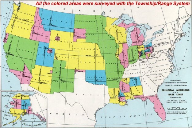
- Section: This is the basic unit of the system. It is a square tract of land one mile by one mile, containing 640 acres.
- Township: 36 sections are arranged in a 6 by 6 system, measuring 6 miles horizontally by 6 miles vertically. Sections are numbered beginning with the northeast-most section, proceeding west to 6, then south to section 7 and then counting back towards the east. See map below.
- Range: Abbreviated “R2W” or similar. The range is assigned to a township by measuring east or west of a Principal Meridian. See map.
- Range Lines: The north to south lines which mark township boundaries.
- Township Lines: The east to west lines which mark township boundaries.
- Principal Meridian: The reference or beginning point for measuring east or west ranges.
- Base line: Reference or beginning point for measuring north or south townships.
The Township and Range
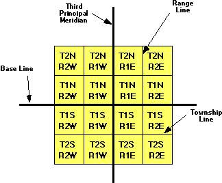 We’ll start with the largest grouping, the township and range. The township is named in reference to a Principal Meridian (P.M.) and a Baseline. Here is an example, T2N R1E. The T2N refers to Township 2 North (of the Baseline), and the R1E refers to Range 1 East (of the Principal Meridian).
Division of Townships into Sections
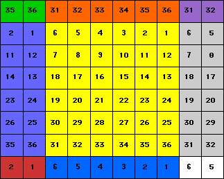
Next, each township is divided into 36 sections. Each section is one mile square and contains 640 acres. The sections are numbered from 1 to 36 in the order shown in the chart to the left.
Divisions Can Also Be Described as Half and Quarter-Sections
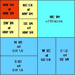
Within each section, the land is referred to as half and quarter sections. A one-sixteenth division is called a quarter of a quarter, as in the NW1/4 of the NW1/4. The descriptions are read from the smallest division to the largest. For instance, you might say that a well is located NW/4 of NW/4 in the section (this would be the red block). Or, you could say the well is located in the E/2 of the SE (that would be the easternmost blue 1/2 quarter section in the lower right corner.
A Section Can Be Broken Down Into Acres
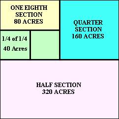 A section is also broken down into acres.
- A full section contains 640 Acres.
- A half section (S1/2) contains 320 Acres.
- A quarter section (NE1/4) contains 160 Acres.
- An eighth section (N1/2 of NW1/4) contains 80 Acres.
- A sixteenth section (SW1/4 of NW1/4) contains 40 Acres.
Locating a Well Using Land Descriptions
A land description generally starts with the smallest part of the description and proceeds to the largest definition. For example, NW1/4 of NE1/4 of Section 8, T2N, R1E would be the northwest quarter of the northeast quarter of section 8 in township 3 north and range 2 east. To locate a well using a land description, you need to work from the largest part to the smallest part.
Township/Range Location Example:
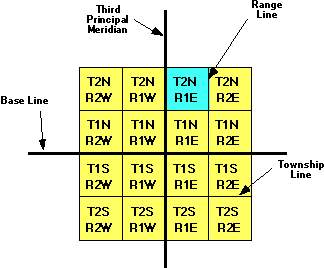 Step 1
As mentioned above, to locate the well given as an example above you would need to work backward and locate the largest part using the township and range supplied in the description first. In this case T2N, R1E. Remember the T2N refers to Township 2 North (of the Baseline), and the R1E refers to Range 1 East (of the Principal Meridian).
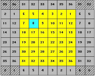 Step 2
After you have located the correct township, you will next need to find the correct section within that township. Using the example given above the land description states Section 8, T2N, R1E. So you would look in the township found in step 1 for section 8.
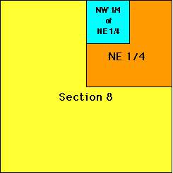 Step 3
Now that you have located the correct section you need to find where in this section your well is located. Our example says NW1/4 of NE1/4 of Section 8, T2N, R1E. So you would first look in section 8 for the NE1/4 of the section (shown as orange in the chart to the left.) After locating the NE1/4 of the section your last step will be to find the NW1/4 of that NE1/4 (shown in aqua in the chart to the left.) The well is generally located at or near the center of the last unit given.
Congratulations!
You’ve successfully located the oil or gas well described in the land description example given above. Good luck in your search for other wells!
Many illustrations on this page are courtesy of Brenda Schnurrer
